
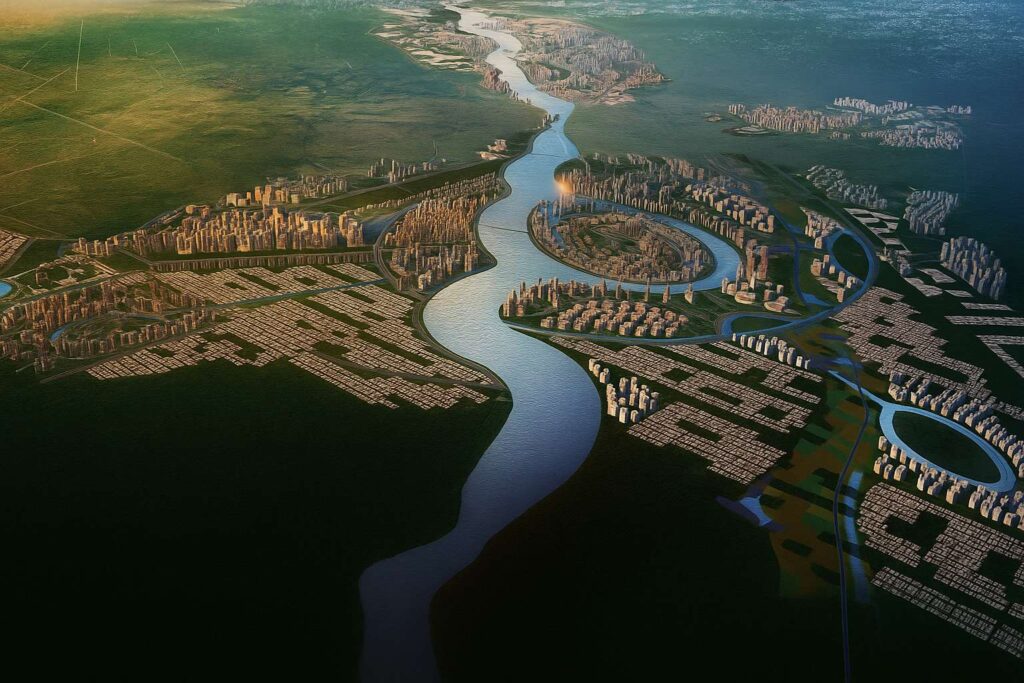
The most ambitious river-adaptive urban development in Pakistan is called Ravi Urban City. It is a planned city that will be built in three phases and span about 46 km along the Ravi, covering about 102,000+ acres (≈41,300 ha). By channeling the Ravi into a managed, perennial water body and enclosing it with public waterfronts, mixed-use districts, and mobility spines, its core brief blends river rehabilitation with city-building.
Scale, Structure & Phasing
- Corridor length: ~46 km along the Ravi River (NE–SW alignment).
- Urbanized area: ~41,308 ha (≈102,074 acres). Some promotional materials claim up to 140,000 acres; architects should reference the lower figure as verified.
- Delivery model: 3 phases, each linked to river training (barrages/impoundments), land development, and precinct rollouts.
Architect’s note: Treat 102,000–140,000 acres as a range—design narratives should anchor to the verified figure, while acknowledging the larger vision envelope.
The Water-First Brief: River Training, Hydrology & Risk
- Channelization in 3 phases: Barrages proposed at the tail of each phase to stabilize levels; islands introduced for placemaking and hydraulic control.
- Base flow augmentation: Reroutes through canal systems intended to maintain permanent water.
- Environmental due diligence: There are several EIAs, but complaints regarding the qualifications of consultants and the thoroughness of the process continue.
- Independent research context:
Architectural implication: Flood-resilient design elements such as podium heights, wet-proofed ground floors, bioswales, and sacrificial lower levels must be incorporated into waterfront architecture.
Master-Plan DNA: Precincts, Themed “Cities,” & Population Logic
- Zone-wise districts include health/medical, innovation, finance, residential, forestry.
- Sources mention 9 precincts and 12 themed cities.
- Population target: ~10 million (long-term, vision scale).
Architectural implication: Supports diverse typologies—medical campuses, modular innovation labs, finance towers, mixed-income housing clusters.
Mobility & Structure Plan
- Wide arterial spines, ~11 proposed river bridges, BRT/Metro links, and water transport nodes.
- RUDA Expressway linking Chahar Bagh & Sapphire Bay.
Architectural implication: Focus on station-area masterplanning—400–800 m walk-sheds, mid-rise density, shaded arcades, active podiums, and bicycle/micro-mobility integration.
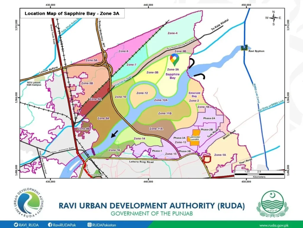
The First Mover: Sapphire Bay (Phase-1)
- Size: ~2,000 acres in Zone-3.
- Consortium: Arif Habib-led (awarded 2021).
- Program: Mixed residential + commercial, renewables, WTPs, waste systems.
Architectural implication: Early phases will lock design codes—façade ratios, shading, plot typologies, river-facing terraces, blue-green levee parks, and rain gardens.
Design Standards for Ravi Urban City
- Waterfront Architecture
- Stepped ghats that can be used as seats.
- Amphitheater coves with wind-comfort features.
- Pavilions for cafes and leisure that are supported by piles or float.
- Climate-Positive Massing
- Ventilated double skins, brise-soleil, and deep overhangs.
- Green roofs and solar-ready roofs.
- Block-scale rainwater reuse systems.
- Human-Scale Podiums
- 3-5 story podiums housing stores, clinics, and childcare facilities.
- Tree-shaded pedestrian boulevards and arcaded walkways.
- Streets & Heat Mitigation
- High-albedo pavements, permeable parking spaces, bioswales.
- Pocket parks are connected by blue-green corridors.
- Affordable Housing Models
- Core-and-shell units that can be expanded.
- Laundry, rooftop PV, and common patios.
- A combination of ownership and rental choices.
Sustainability & Ecology
- Goals: River restoration, green spaces, sanitation.
- Vision targets: 46 km lake, ~6 million trees (verification pending).
Architect’s due diligence lenses:
- Water source and quality control.
- Management of sedimentation and erosion.
- Coverage of WWTP before to occupation.
- Strategies for biodiversity net gain.
Governance & Social License
Legal & procedural scrutiny: There have been court petitions and protests challenging land acquisition methods and questioning EIA processes (e.g., consultant registration). These narratives affect investor confidence and community trust—be prepared with transparent engagement plans and compliance checklists. (source)
Procurement history: Earlier EOIs/RFPs via LDA/RUDA outlined consultancy scopes for master-planning, environmental sustainability, and preparatory works. Keep your document control tight—use latest gazettes/maps. (source), (source)
Architecture opportunity map
- Riverfront blocks: mixed-use ribbons, stepped terraces, and ground floors that are flood-compatible.
- Transit districts: car-lite streets, hybrid programs, and mid-rise density.
- Amphitheaters, river museums, and reimagined Mughal-inspired crafts make up the civic spine.
- District energy pilots and modular labs are examples of innovation/health campuses.
- Courtyard blocks, shared terraces, and incremental housing are examples of affordable clusters.
A realistic status check (2025)
- Sapphire Bay is marketed as the earliest, active phase; realty trackers continue to post updates through 2025. Verify on-ground progress (roads, services, utilities) before committing occupancy dates or sales narratives. (source)
- Promotional content references expressway links (e.g., Chahar Bagh–Sapphire Bay) and continuous master-plan reveals in 2025—treat as in-progress until backed by official gazettes/contract awards. (source), (source)
Architect’s Checklist: Risks & Responsibilities
- Flood design: Freeboard + non-catastrophic failure modes.
- WWTP sequencing: Infrastructure first.
- Heat & air quality: Shading + HVAC filtration.
- Social equity: Inclusive public riverfront access.
- Governance: ESG covenants, verified EIAs.
FAQ your clients will ask (with quick answers)
- Is the riverfront “real” water or just landscaping? The intent is a managed perennial channel using barrages and controlled flows; exact hydrological performance depends on upstream allocations, canal diversions, and treatment efficacy. (source), (source)
- How many people will live here? Vision ranges up to ~10 million in some materials; treat as long-term capacity, not a near-term target. Design for phased, mixed-income growth. (source), (source)
- What’s first to be built? Sapphire Bay precinct works are the earliest publicly marketed component; due diligence on utilities/roads is essential before fit-outs. (source), (source)
- Are there controversies? Yes—EIA procedure and land acquisition have faced legal/activist scrutiny. Plan for robust compliance and community engagement. (source)
Sources & further reading
Project overview, scale & phasing: Wikipedia (summary of official briefs). (source)
RUDA official site (vision, maps/gazettes). (source)
LDA EOI (2020) for preparatory works & sustainability remit. (source)
River training & channelization narratives (three phases, barrages, islands). (source)
Environmental critiques & legal challenges: Dialogue Earth. (source)
Phase-1/Sapphire Bay (developer & market sources). (source) (source), (source)
2024–2025 academic/market context on hydrology/flood risk & master-plan claims. (source), (source), (source)
Tree/lake claims and general features (treat as vision statements pending official gazettes). (source)
Closing Note
If Lahore is to grow without repeating the mistakes of car-centric sprawl and untreated effluent, Ravi Urban City has to be more river project than real estate project. For architects, that means the urban language starts with hydrology, heat, and habitat, then layers mixed-use life on top. Get the water, shade, and access right—and the skyline will follow.